Quick Stats
Expedition Date: Oct. 10-12, 2025
Trail Name: Cohutta Wilderness Loop (unofficial)
Region: Cohutta Wilderness, GA / TN Border
Trail Type: Clockwise Loop
Distance: ~60 miles (loop and side routes combined)
Drive Time: 10-12 hours with stops
Difficulty: Mild – Moderate (some rocky climbs, occasional washouts, one low water crossing)
Vehicle Requirements: 4WD / High Clearance (33”+ tires recommended)
Best Season: Late Spring through Fall
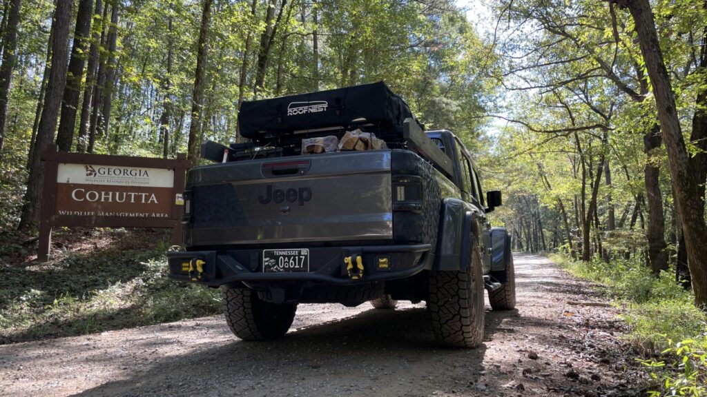
Access Point: Eton, GA (entered via FS 18 near Old CCC Camp Road)
Permits / Fees: None required
Notable Closures: FS 294 closed due to washed-out bridge
Coordinates (Trailhead): 34.8884, -84.7292
Map: View on OnX Offroad
Overview
The Cohutta Wilderness Loop sits on the Georgia–Tennessee border, weaving through the Cohutta and Big Frog Wilderness regions. It’s a scenic, lightly trafficked trail system with a mix of smooth forest service roads and more technical rocky climbs. Water crossings, ridge views, and quiet forest camping make it one of North Georgia’s more rewarding moderate loops for overlanders looking for solitude without extreme difficulty.
Getting There
I met my co-pilot — Uncle Larry, a retired vet and avid outdoorsman — in Chatsworth, Georgia, where we stocked up on supplies at Food City. From there, we entered the wilderness via Eton, starting the loop clockwise. The approach roads were well maintained, and fuel, groceries, and a few local eateries are readily available in Chatsworth before heading into the forest.
Trail Breakdown
Leg 1: Eton to Big Frog Wilderness (0–20 mi)
- Terrain: Gravel and dirt mix, light washboarding
- Key Waypoint: Small lake near Sina Branch Rd
- Notes: Met fellow Jeepers Victor and Matthew, Georgia locals familiar with the route, who guided us part of the way northward.
Leg 2: Sina Branch Rd to Overnight Camp (20–25 mi)
- Terrain: Narrow forest road with light brush
- Camping: Backtracked about 3 miles from Parksville Lake to a perfect dual-rig site on Sina Branch Road
- Notes: Quiet, secluded, no mosquitos to speak of, excellent tent or rooftop setup area.
Leg 3: Morning Depart to FS 221 and FS 6 (25–50 mi)

- Terrain: Gravel ridgelines, rocky climbs
- Highlights: Smooth early morning drive with light fog lifting over the forest canopy
- Lunch Stop: Simple cold sandwiches and chips near FS 6 junction
Leg 4: FS 294 Closure / Creek Crossing (50–55 mi)
- Notable: FS 294 currently closed due to a washed-out bridge
- Observation: Concrete barricades prevent large vehicles from proceeding. A narrow gap allowed a test crossing — successful in a lifted Gladiator on 35s — but the opposite end of the bridge was fully barricaded again just 300 yards ahead.
- Recommendation: Do not attempt to bypass; reroute to Thunder Rock Campground.
Leg 5: Exit and Return (55–60 mi)
Exited trail near Thunder Rock Campground, aired up, and continued toward Blue Ridge, GA to enjoy other attractions.
Conditions (At Time of Report)
- Surface: Mostly dry, moderate dust, mild erosion on steeper climbs
- Water Crossings: One shallow creek crossing, firm rocky base, ~10–12” depth
- Weather: Mid-70s by day, low 50s overnight. Calm, few bugs.
- Closures: FS 294 bridge washout confirmed (impassable to full-size vehicles)
Camping + Points of Interest
- Sina Branch Primitive Site: Ideal for 1–2 rigs, level ground, shaded, near running water
- Thunder Rock Campground: Developed site with facilities, perfect for airing up before hitting pavement
- Bigfoot Expedition Museum (Blue Ridge, GA): Fun and quirky detour for those chasing Appalachian legends
Navigation + Gear Notes
- Mapping: OnX Offroad{:target=”_blank” rel=”noopener”} offline maps used throughout
- Comms: GMRS radios for convoy chatter
- Recovery Gear: Not needed, but a shovel and traction boards are smart backup due to potential washouts
- Tires: 35” ATs handled the terrain easily; airing down to 18 PSI recommended
Summary + Recommendations
The Cohutta Wilderness Loop offers a great blend of relaxed forest cruising and moderate off-road adventure. It’s ideal for those new to the Cohutta region looking for an approachable, scenic overland weekend route with reliable camp options.
If you plan to run the full loop, check current road closures before departure and expect to reroute around FS 294.
For us, the trail delivered everything you want out of a weekend on dirt: good company, a campfire meal under still skies, and a reminder that sometimes the detour is the destination.
Post-Trip Bonus
- Local Attraction: Expedition Bigfoot Museum, Blue Ridge, GA
- Dinner Stop: Taco Tsunami in Gainesville, GA
- Event: Super Overland Outfitters monthly meetup — 40+ rigs, gear raffle, and great community vibes
Tread lightly and Gladiator Up! – Doug
Disclaimer
All trail details are accurate as of this trip’s report. Conditions change frequently — always verify closures and travel at your own risk. This post is for informational and entertainment purposes only.
Your article helped me a lot, is there any more related content? Thanks!
Equilibrado de piezas
El equilibrado representa una fase clave en las tareas de mantenimiento de maquinaria agricola, asi como en la fabricacion de ejes, volantes, rotores y armaduras de motores electricos. Un desequilibrio provoca vibraciones que incrementan el desgaste de los rodamientos, generan sobrecalentamiento e incluso llegan a causar la rotura de componentes. Para evitar fallos mecanicos, es fundamental detectar y corregir el desequilibrio a tiempo utilizando metodos modernos de diagnostico.
Principales metodos de equilibrado
Existen varias tecnicas para corregir el desequilibrio, dependiendo del tipo de pieza y la intensidad de las vibraciones:
El equilibrado dinamico – Se utiliza en componentes rotativos (rotores y ejes) y se realiza en maquinas equilibradoras especializadas.
Equilibrado estatico – Se usa en volantes, ruedas y otras piezas donde es suficiente compensar el peso en un unico plano.
Correccion del desequilibrio – Se lleva a cabo mediante:
Perforado (retirada de material en la zona de mayor peso),
Colocacion de contrapesos (en ruedas, aros de volantes),
Ajuste de masas de equilibrado (como en el caso de los ciguenales).
Diagnostico del desequilibrio: ?que equipos se utilizan?
Para identificar con precision las vibraciones y el desequilibrio, se utilizan:
Equipos equilibradores – Miden el nivel de vibracion y determinan con exactitud los puntos de correccion.
Analizadores de vibraciones – Registran el espectro de oscilaciones, identificando no solo el desequilibrio, sino tambien otros defectos (por ejemplo, el desgaste de rodamientos).
Sistemas de medicion laser – Se usan para mediciones de alta precision en componentes criticos.
Las velocidades criticas de rotacion requieren especial atencion – condiciones en las que la vibracion se incrementa de forma significativa debido a fenomenos de resonancia. Un equilibrado adecuado evita danos en el equipo en estas condiciones de funcionamiento.
Your article helped me a lot, is there any more related content? Thanks! https://accounts.binance.com/en-ZA/register-person?ref=B4EPR6J0
Can you be more specific about the content of your article? After reading it, I still have some doubts. Hope you can help me.
I don’t think the title of your article matches the content lol. Just kidding, mainly because I had some doubts after reading the article. https://accounts.binance.info/ar/register-person?ref=FIHEGIZ8
Thank you for your sharing. I am worried that I lack creative ideas. It is your article that makes me full of hope. Thank you. But, I have a question, can you help me?
I don’t think the title of your article matches the content lol. Just kidding, mainly because I had some doubts after reading the article.
Ola, quería saber o seu prezo.
Can you be more specific about the content of your article? After reading it, I still have some doubts. Hope you can help me.
Your article helped me a lot, is there any more related content? Thanks!
Your point of view caught my eye and was very interesting. Thanks. I have a question for you.